With the disturbances in the campground the night before
cutting into my beauty sleep, I crawled out of the tent at the rather late hour
of 8 am. I quickly started packing up my gear, ate a quick breakfast, washed my
face with my handy wet wipes, and was ready to leave my old home town by around
9 am.
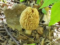
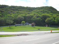
Before taking off, I took a few pictures around my campsite of the view of the twin old and new bridge spans climbing up and over the Main Channel of the River above my campsite, and almost stepped on some wrinkly looking light colored mushrooms that grew along the shoreline between me and the backwaters.
Before taking off, I took a few pictures around my campsite of the view of the twin old and new bridge spans climbing up and over the Main Channel of the River above my campsite, and almost stepped on some wrinkly looking light colored mushrooms that grew along the shoreline between me and the backwaters.
I thought
the mushrooms looked like the famous morels I had heard about and looked at the
trees to see if I could figure out if they were elms that the mushrooms were
apparently so fond of. Since there were
quite a few of the mushrooms, and I had heard how tasty they could be, I
thought about picking some, but as I had nothing to cook them with and wasn’t
sure about their identity, I decided to leave them grow to maturity in peace. I stopped at the campground restroom to fill
my bottles with the rusty/cloudy campground water and hoped it was safe to
drink and headed back across the waters to Minnesota.
Getting back to the Great River Road, I noticed that the
State of Minnesota had also designated the road as the “Disabled American
Veterans Highway”. I wondered how many
disabled veterans found that tactic an honor, or how many motorist even noticed
the small green designation sign as they sped by? All I knew for sure was that if I had been a
veteran and been disabled, and had to go through some of the hassles I have
heard about in trying to get proper care and treatment for the damages they
suffered due to war, I didn’t think I would feel honored by such a tribute, but
that is only me speaking after my minor inconvenience of waking up grumpy after
having my sleep interrupted – which is nowhere near the inconvenience suffered
by disabled veterans – so I tried to let that thought go.
And speaking of disabled creatures – I passed a large number
of turtles that had been hit by passing motorists speeding across the filled in
areas of the water way. Their crushed
shells were a reminder of how we seem to take it for granted that it is
acceptable to design our highways with little if any regard for the other
creatures that need to travel along the roadways – especially if it would mean
added design expenses. So we simply
waste the turtles so we don’t have to waste our time or money. And then that got me thinking about how our
society seems to thrive on the whole concept of waste. A green Waste Management semi-truck passed me
by, and I thought about how we have created whole industries who profit from
our wasteful practices, and then we create government agencies like the
Minnesota Pollution Control Agency I worked for when I was not taking leaves of
absence to go for extended bike rides who try to set up rules and regulations
to manage how we manage all the waste.
Waste seemed to be the common theme that was jumping out at
me on what I had been experiencing on my travels. We wasted ground water to wash our cars, we
wasted it to water our lawns and irrigate our crops that often times was used
produced the ethanol that in part fueled our cars, and then we wasted it to
move our human wastes from our bathrooms to somewhere else where we didn’t need
to see it, smell it, or think about it.
And then we produced stuff we didn’t really need, but thought we did
because of the brainwashing we received since birth that the accumulation of
stuff was the meaning of life, and that more stuff meant we would be safer in
the future. So we pursued more stuff
instead of looking for the happiness within ourselves, along with bigger stuff,
or stuff that made more noise or burned more fuel faster, or got us somewhere
away from where we were faster.
And then in the process of making all that stuff, we created
industrial waste, or hazardous waste, or waste we didn’t even know how to
classify or what the consequences of disposing it would be. And in the past these practices produced Superfund
sites, or groundwater cleanup sites, or landfills, or wastewater treatment
plants. But we thought we were safer,
despite the new threats that made us more afraid. And then the fertilizers we used to produce
our food and our fuel and our green bio-plastics ended up as waste when it ran
off the land and into the Mississippi River and ended up wasting the life in
the Gulf of Mexico creating “dead zones” where life no longer existed – at
least life as we used to know it in that place.
So then we tried to create refuges for life by skimming off some of the profits
from the whole waste lifestyle we lived and diverted it back to our feel good
refuges, our parks, our preservers, our public service agencies, and non-profit
organizations – so that we could keep wasting our resources on our wasted
life’s. And then we create armies and
munitions to defend this whole way of life, because as we had been told and
sold on the line that “freedom isn’t free”, it costs lives and of course
dollars as well.
So I decided to stop wasting my time and start peddling faster as I passed another Kwik Trip, where I saw another green John Deer lawn tractor being pulled behind a truck and fueled up with $3.999 per gallon ethanol blended gas and hit the “Theodore Foss Memorial Highway”, which was also still the “Great River Road”, as well as the “Disabled American Veteran Highway”.
Corporal Foss was a State Trooper who was killed on the highway while making a traffic stop on August 31st, 2000 on Interstate 90, which I found myself traveling down for a short while. And while pulling in to the rest stop at the Lock and Dam, I noticed more construction going on adjacent to the multi-memorialized road which besides it I90 designation also contained US Highways 14 and 61.
I would thankfully soon exit the much traveled Interstate and
follow the Great River Road up Highway 61 North to Winona, but in the meantime
I had some more internal conversations about how many other lives had been
wasted or disabled by simply getting in car “accidents” along the memorial
highway, the passengers and drivers who went unrecognized for giving up their
lives in pursuit of achieving their own version of the American Dream. I had passed many a makeshift memorial to
those poor lost souls along my journey down and up the Great River Road – the fading
plastic flower wreathes hung on a right-of-way marker or strapped to a guard
rail, the painted wooden crosses with a name and date scribed on it pounded
into the ditch next to the road – but never a formal state sponsored plaque or
marker along the roadside. We seemed to
take for granted that ultimate cost of our freedom to drive our cars wherever
we wanted, whenever we wanted – or at least we in the business of governing
didn’t like to promote such memories – as it might tend to turn our dream into
a nightmare.
As I exited the Theodore Ross Memorial Highway, I noticed
more large homes propped up on the upper levels of the bluffs – more memorials
to that ultimate American Dream of the big house on the hill overlooking the
river valley, a place to drive up and down to every day to get away from the
places we drove up and down to in order to support our lifestyles – that
carried away our negative thoughts with their awe-inspiring views.
And then I passed by one of the remnants of
the most popular fruits amongst the travelers of the Great River Road based on
the number of peels I passed (and one of my favorites on this trip as well) –
the Guatemalan grown and cloned banana peel.
In this particular case determining the home of the peel was possible
because of the permanent plastic label left on the peel before placing it on
the passing pavement where it was thought it would perish and not be noticed by
a passerby-er. Being organic in nature,
many drivers of the Great River Road found it more convenient to simply toss the
peel out their powered car window, than to leave them fester in the car until
they got to their destination to properly dispose of.
What is interesting about the banana peel on
the paved shoulder of the road is that with heat and drying, the yellow soft
peel transforms into a hard almost huge black spider like object that perhaps
survives for many years in this desiccated form. The discarded peel reminded me of an incident
that happened to me while walking along a side-walk half a lifetime ago while
going to college back in Platteville where I was walking along and then slipped
on a fresh banana peel and nearly did the splits, in front of a busload of
onlookers. It was amazing to me what
memories a banana peel could bring back from the past.
Then I passed another pile of desiccated remnants – bones
this time, and deer bones in particular, which could be properly identified by
the black cloven hoof, still intact at the base of the tibia and fibula of the
fallen deer, but there was no skull – where did it go? I now understood where the term “bone dry”
came from.
Then I passed by another
reminder of bones – a mound – but unlike the mounds left behind by the previous
folks who inhabited the land a thousand years ago, this modern mound was
constructed to honor our waste – excrement in this case – which likely was due
to high groundwater making disposal of the waste in a conventional in ground
septic system ineffective, so the raised mound was installed. Some day in the distant future, archeologists
would likely excavate that mound thinking it was a burial site for some
important noble man or woman, only to
find excrement and perhaps a few other treasures that might have mistakenly
been flushed down the porcelain god of the past. The conclusion likely would be that these
former inhabitants foolishly worshiped their waste, which was the likely reason
they perished and no longer inhabited the land.
With all this stuff on my mind, and despite all the stuff on my bike, the relatively flat miles to Winona passed
in what seemed like no time and I found myself passing by the billboards that
line the highway outside of the Cities advertising where enticing stuff could
be purchased. And one billboard that
stuck out was from the Mainstream Firearms & Marine store which was home to
over “1000 Guns”, the “Go-Devil” boat, and pawn shop. For the more stuff you had, the more guns you
would need to protect yourself from those who had less.
And then something else stuck out, the rock
formation above Winona known as “Sugar Loaf” which was a remnant of quarrying activities
that took place on the bluff back in the late 1800’s where the limestone was
used to build sidewalks and buildings in the City of Winona below.
Feeling a need for a sidewalk escape from the highway to stuff and waste I had been stuck on for most of the morning, I detoured on to the path the ran between the highway and adjacent Lake Winona and reclaimed some sense of peace as I passed pedestrians out for a midday stroll or jog along the path. At one point I passed a young mother pointing out the fish swimming amongst the near shore plants to her even younger daughter, which renewed my sense of hope, perhaps foolishly.
Feeling a need for a sidewalk escape from the highway to stuff and waste I had been stuck on for most of the morning, I detoured on to the path the ran between the highway and adjacent Lake Winona and reclaimed some sense of peace as I passed pedestrians out for a midday stroll or jog along the path. At one point I passed a young mother pointing out the fish swimming amongst the near shore plants to her even younger daughter, which renewed my sense of hope, perhaps foolishly.
I realized a need to get out of the mindset I was in,
plugged in the previously repaired IPod headphones to my ears, turned up the music and tried just
pedaling in order to achieve that meditative mindless state. I was hoping to make it to Lake City that
night, a place I knew to be about half way between La Crosse and home, which if
I could make it to would place me almost with in one more day of peddling to my
home and out of my mind which was starting to sound a bit crazy to me. It also might allow me to reach that elusive
goal of the 100 mile day in that last stretch to home, something else that
seemed like a worthwhile goal, if for no other reason than to be able to say
that at least for one day I had traveled 100 miles on a bike.
Before I knew it I was in the small riverside town of
Minneiska where I stopped for a moment to rest in the shade of the larger than
life roadside mostly blue and green mural depicting the river valley below that
had been painted on the large retaining wall besides the side road overlooking
the river valley below.
And what seemed
but a short time later, I was in another small town of Kellogg passing its
sky-blue colored water tower topped by the old “red, white, and blue, all
backed by a blue sky, where shortly later I passed another large green lawn
nestled below the bluffs being mowed by another green John Deer lawn tractor with a sign out front that
declared the place was “Nearly A Ranch” – of lawn that was.
Then there was the huge sand pile that had been deposited alongside the highway by the main channel dredgers – likely to be processed by some purveyor of sand for profiting from some unknown usage of the extra-large bulk quantity of silica material.
Then there was the huge sand pile that had been deposited alongside the highway by the main channel dredgers – likely to be processed by some purveyor of sand for profiting from some unknown usage of the extra-large bulk quantity of silica material.
Which then lead me to the Lake Pepin plaque placed by the
Geological Society of Minnesota that declared:
Lake
Pepin occupies the Mississippi Valley above this point for a distance of 22
miles. The lake is formed by the delta
of the Chippewa River which enters the Mississippi directly east of this site.
The
Chippewa, a relatively small river, has a much steeper gradient than that of
the Mississippi. It was therefore able
to transport more sand and coarser gravel than the master stream could
remove. In consequence the Mississippi
was dammed back in the gorge to form Lake Pepin.
The
surface of the lake is 664 feet above sea level and 450 feet below the top of
the bluffs which line its shores.
The
sand and limestone walls of the gorge are composed of material deposited in
Cambrian and Ordovician seas when the continent was submerged some 400 million
years ago.
The
bottom of the gorge is 150 feet below the lake surface having been filled to
its present elevation as the carrying power of the river decreased.
In the state of mind I had been in on that particular day, I
wondered when an addendum to the plaque would be added that would describe how
the Lake was eventually filled in by the sediment that was carried downstream
to the lake by some other feeder rivers – namely the Minnesota – that drained the
agricultural lands that dominated the State Minnesota’s interior lands, eventually
filling in the once large lake – and putting an end to the dominance of
agriculture on the then soil depleted former prairie lands.
I went by a marina filled with sailboats safely secured, stopped at the first inn of the town only to learn the cheapest stay was a whopping $150 a night, and was referred to the lower cost motels a few blocks up the lake. There I settled for the Sunset Motel, for a more reasonably priced $68 per night. I carried my bike up the three steps to my room, unpacked my stuff, showered; walked over to the adjacent Burger King for a Veggie Burger, large fry, and a smoothie; and polished them off in my room where I soon called it a night. I had made it 73 miles, despite my negative outlook, and it felt good to be home for the night, and perhaps one day more of peddling from my home of old.


No comments:
Post a Comment